Queenstown

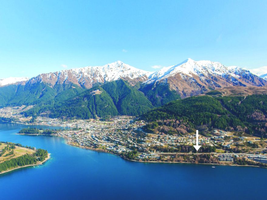
Queenstown town and Lake Wakatipu below the Remarkables2 for sale
Queenstown on Lake Wakatipu. Photo: Bernard Spragg, CC0, Wikimedia Commons. Resized.

A lakeside resort town on Lake Wakatipu.

  • 2Berry homes for sale hereBerry listings, today
  • 1state school within 2.5 kmMinistry of Education, 29 Oct 2026
  • 306–1706 mheight above sea level, 12 km squareTerrain Tiles on AWS (Terrarium; NZ heights from LINZ)
  • 23sourced facts on this page, 8 from government or councilevery one has a source

See Queenstown on the map

2 for sale

For sale in Queenstown (2)

2 on Berry now

Who buys here

Ask a Berry agent

Who is buying changes through the year, and we do not publish a figure we cannot source. Ask a Berry agent who they are seeing here.

What you get (3)

Queenstown sits on the northwestern edge of Lake Wakatipu, near where…
  • Queenstown sits on the northwestern edge of Lake Wakatipu, near where the Frankton Arm meets the main lake, with The Remarkables range to the southeast. Wikipedia · accessed 2026-10-28
  • The Queenstown urban area had an estimated population of 29,000 as of June 2025, within a district of about 53,800 people. unsure: Stats NZ estimate read via Wikipedia, not a census count; Stats NZ page not opened directly. Wikipedia (citing Stats NZ subnational estimates) · June 2025 estimate
  • The town lies at about 310 m above sea level at the lake shore. unsure: The infobox gives 330 m while the text gives 310 m at the lake shore. Wikipedia · accessed 2026-10-28

Schools (4)

Queenstown Primary School is a co-educational state primary school for…
  • Queenstown Primary School is a co-educational state primary school for Years 1 to 8, with a roll of 514. Wikipedia (citing Ministry of Education directory) · July 2026 roll
  • St Joseph's School in Queenstown is a co-educational Catholic state-integrated primary school for Years 1 to 8, with a roll of 128. Wikipedia (citing Ministry of Education directory) · July 2026 roll
  • Wakatipu High School is a co-educational state secondary school for Years 9 to 13 at Red Oaks Drive, Frankton, with a roll of 1,538; it moved from central Queenstown over the 2017/18 summer. Wikipedia · July 2026 roll
  • Frankton also has Remarkables Primary School (state, Years 1-8, roll 417) and KingsView School (state-integrated, Years 1-8, roll 80); Shotover Primary School in Shotover Country has a roll of 564. Wikipedia (citing Ministry of Education directory) · July 2026 roll

Getting around (3)

Queenstown Airport is at Frankton, about 7 km east of the town centre…
  • Queenstown Airport is at Frankton, about 7 km east of the town centre along State Highway 6A, with domestic flights and international services to Australian cities. unsure: The 7 km figure is the Frankton-Queenstown distance along SH6A, not a measured terminal-to-centre distance. Wikipedia · accessed 2026-10-28
  • State Highway 6 passes through Frankton, and a 9 km spur, SH6A, runs from Frankton to the town centre. unsure: This page says 9 km for SH6A; the Frankton page says about 7 km. Wikipedia · accessed 2026-10-28
  • Otago Regional Council runs the Queenstown public bus network, with routes including 1 Sunshine Bay - Remarkables Shops, 2 Frankton Hub - Arrowtown, 3 Kelvin Heights - Quail Rise, 4 Jacks Point - Arrowtown and 5 Lake Hayes Estate - Queenstown. Otago Regional Council · accessed 2026-10-28

Natural hazards (4)

Otago Regional Council says there is a 75% probability of an Alpine…
  • Otago Regional Council says there is a 75% probability of an Alpine Fault earthquake in the next 50 years, probably magnitude 8+, and that significant building damage can be expected in the Queenstown Lakes District. Otago Regional Council · accessed 2026-10-28
  • ORC expects an Alpine Fault rupture to cut road access through the Kawarau Gorge and between Kingston and Frankton, with liquefaction and countless landslides. Otago Regional Council · accessed 2026-10-28
  • Lake Wakatipu flooding of the Queenstown stormwater system becomes possible at about 311.3 m; the November 1999 flood peaked at 312.8 m. unsure: Threshold is implied (forecast 311.4 m stated as 0.1 m above it); release is from 2019. Otago Regional Council · 5 December 2019
  • Council-commissioned work found rockfall and debris-flow risk on the Brewery Creek and Reavers Lane fans off Gorge Road, Queenstown; engineering works and rockfall fencing were the preferred responses. unsure: 2022 release; a June 2026 reassessment exists but was not opened, and the final council decision was not found. Queenstown-Lakes District Council · 29 April 2022

Read more

Shops, climate, sale figures, map and tour, guides

Shops, health and things to do

  • Lakes District Hospital at 20 Douglas Street, Frankton, has a 24-hour emergency department, entered from Lucas Place. Health New Zealand · accessed 2026-10-28
  • PAK'nSAVE Queenstown is at 302 Hawthorne Drive, Frankton, open 7am to 10pm daily. PAK'nSAVE · accessed 2026-10-28
  • The council-owned Queenstown Events Centre on Joe O'Connell Drive, Frankton, includes Alpine Aqualand with a 25 m eight-lane lap pool, leisure pool, lazy river, two hydroslides and learners' pools. Wikipedia · accessed 2026-10-28
  • Queenstown Gardens, on a peninsula beside the town centre, was established in 1867 and has a pond, playground, tennis and lawn bowls. Wikipedia · accessed 2026-10-28
  • The Queenstown Trail is a network of at least 130 km of trails linking Queenstown, Arrowtown, Jack's Point and Gibbston. Wikipedia · accessed 2026-10-28

Climate

  • At Queenstown Airport, mean daily highs run from about 22.0 C in January to 8.2 C in July, and the July mean low is -1.4 C (1991-2020 normals). Wikipedia (citing NIWA) · 1991-2020 normals
  • Queenstown Airport averages about 721 mm of rain and 1,899 sunshine hours a year. Wikipedia (citing NIWA) · 1991-2020 normals
  • The Queenstown Gardens station, closer to the town centre, is milder and wetter, averaging about 909 mm of rain a year. Wikipedia (citing NIWA) · 1991-2020 normals
Average daily low to high, °C
020Jan: 9.9° to 22°CJFeb: 9.5° to 21.8°CFMar: 7.3° to 19.1°CMApr: 4.5° to 15.2°CAMay: 2.3° to 11.9°CMJun: -0.4° to 8.6°CJJul: -1.4° to 8.2°CJAug: 0.2° to 10.2°CASep: 2.4° to 13°CSOct: 4.4° to 15.4°CONov: 6.2° to 17.5°CNDec: 8.5° to 20.2°CD
Average rain, mm a month
075Jan: 71.6 mmJFeb: 51 mmFMar: 49.3 mmMApr: 57.5 mmAMay: 75.1 mmMJun: 62.2 mmJJul: 55.8 mmJAug: 52.8 mmASep: 62.3 mmSOct: 62.4 mmONov: 60.7 mmNDec: 60.3 mmD
The same figures as a table
MonthLow °CHigh °CRain mm
Jan9.92271.6
Feb9.521.851
Mar7.319.149.3
Apr4.515.257.5
May2.311.975.1
Jun-0.48.662.2
Jul-1.48.255.8
Aug0.210.252.8
Sep2.41362.3
Oct4.415.462.4
Nov6.217.560.7
Dec8.520.260.3

Queenstown Airport (NIWA 1991-2020 normals) · Wikipedia climate table (citing NIWA) · 1991-2020 normals

What homes sell for (public figures)

  • QV's May 2026 index put Queenstown's average home value $58,268 short of $2 million, after a 1.2% rise over the quarter. unsure: District-level figure (QV 'Queenstown'), not suburb-level; newer months not found on the QV page. QV · May 2026 index (released 9 June 2026)

On the map, and a short tour

Queenstown on the Berry map: simple, topographic, aerial where available, or 3D with buildings and terrain, with schools and hikes nearby and the Berry homes for sale.

See Queenstown on the map

  1. Town centre — Lakefront town centre on Lake Wakatipu, where high lake levels can back up the stormwater system. Show on the map: Town centre en.wikipedia.org
  2. Queenstown Gardens — Peninsula park beside town, established 1867, with playground, tennis and bowls. Show on the map: Queenstown Gardens en.wikipedia.org
  3. Wakatipu High School, Frankton — The district's state secondary school for Years 9-13, near the airport. Show on the map: Wakatipu High School, Frankton en.wikipedia.org
  4. Frankton — Airport, hospital, events centre pools and the large supermarkets are clustered here. Show on the map: Frankton en.wikipedia.org

Stops are placed from published coordinates and are approximate. The map's data sources and licences are listed under "Data and licences" on the map.

Guides

Short guides for buyers, sellers and owners. Start with the LIM report.

23 facts, each with its public source and date; 7 marked unsure. Council: Queenstown-Lakes District Council. Checked 28 Oct 2026. Nothing here is advice; check the LIM and council maps for a particular property.

Berry agents selling in Queenstown

Thinking of selling in Queenstown?

An agent comes and looks. We do not put a number on a home from a web page.

Your name and phone can follow on the next page, if you like. We email the address to Berry's appraisals inbox and send you a copy. Nothing goes to anyone else. Berry Real Estate Limited collects these details to arrange your appraisal. Giving them is voluntary. See or correct them (Privacy)